


St Roman de Codiere

guyzinz
User
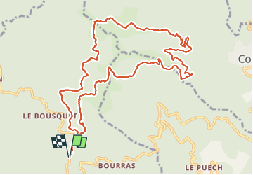

Length
14.1 km

Max alt
901 m

Uphill gradient
481 m
Km-Effort
21 km

Min alt
658 m

Downhill gradient
481 m
Boucle
Yes
Creation date :
2021-06-01 08:15:18.163
Updated on :
2021-06-01 13:04:32.175
4h15
Difficulty : Medium

FREE GPS app for hiking
 SityTrail
IGN / Geographical institutes
SityTrail Plus
The world is yours!
About
Trail Walking of 14.1 km to be discovered at Occitania, Gard, Saint-Roman-de-Codières. This trail is proposed by guyzinz.
Description
le Col de la Pierre Plantée
Photos


Positioning
Country:
France
Region :
Occitania
Department/Province :
Gard
Municipality :
Saint-Roman-de-Codières
Location:
Unknown
Start:(Dec)
Start:(UTM)
562415 ; 4873358 (31T) N.
Comments