


les sources de la dordogne puy gros 17 km

jeanic63
User

Length
17.7 km

Max alt
1474 m

Uphill gradient
903 m
Km-Effort
30 km

Min alt
888 m

Downhill gradient
903 m
Boucle
Yes
Creation date :
2021-06-02 06:58:29.668
Updated on :
2021-06-07 15:49:09.027
6h37
Difficulty : Very difficult

FREE GPS app for hiking
 SityTrail
IGN / Geographical institutes
SityTrail Plus
The world is yours!
About
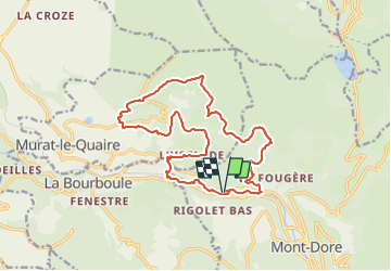
Trail On foot of 17.7 km to be discovered at Auvergne-Rhône-Alpes, Puy-de-Dôme, Mont-Dore. This trail is proposed by jeanic63.
Description
départ parking de l'ancienne usine de la taillerie sur la D 996
Positioning
Country:
France
Region :
Auvergne-Rhône-Alpes
Department/Province :
Puy-de-Dôme
Municipality :
Mont-Dore
Location:
Unknown
Start:(Dec)
Start:(UTM)
483098 ; 5048206 (31T) N.
Comments