Saint-Hubert 03 juin 21

pierlan
User
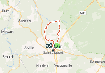

Length
15.3 km

Max alt
582 m

Uphill gradient
400 m
Km-Effort
21 km

Min alt
414 m

Downhill gradient
399 m
Boucle
Yes
Creation date :
2019-01-15 18:48:10.669
Updated on :
2021-06-02 07:44:47.05
1h28
Difficulty : Unknown
3h00
Difficulty : Very easy

FREE GPS app for hiking
 SityTrail
IGN / Geographical institutes
SityTrail Plus
The world is yours!
About
Trail Walking of 15.3 km to be discovered at Wallonia, Luxembourg, Saint-Hubert. This trail is proposed by pierlan.
Positioning
Country:
Belgium
Region :
Wallonia
Department/Province :
Luxembourg
Municipality :
Saint-Hubert
Location:
Unknown
Start:(Dec)
Start:(UTM)
669982 ; 5544207 (31U) N.
Comments