


2021-06-02_20h43m49_RP_foret marly_princesse

philberard95
User
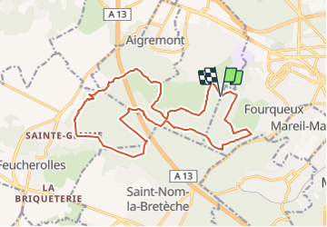

Length
18.3 km

Max alt
194 m

Uphill gradient
290 m
Km-Effort
22 km

Min alt
107 m

Downhill gradient
291 m
Boucle
Yes
Creation date :
2021-06-02 18:43:49.67
Updated on :
2021-07-02 16:13:08.79
5h02
Difficulty : Very difficult

FREE GPS app for hiking
 SityTrail
IGN / Geographical institutes
SityTrail Plus
The world is yours!
About
Trail Walking of 18.3 km to be discovered at Ile-de-France, Yvelines, Chambourcy. This trail is proposed by philberard95.
Positioning
Country:
France
Region :
Ile-de-France
Department/Province :
Yvelines
Municipality :
Chambourcy
Location:
Unknown
Start:(Dec)
Start:(UTM)
429958 ; 5415622 (31U) N.
Comments