


course

randolea
User
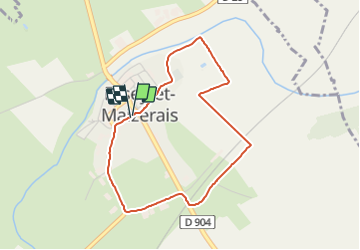

Length
3.4 km

Max alt
238 m

Uphill gradient
26 m
Km-Effort
3.8 km

Min alt
216 m

Downhill gradient
27 m
Boucle
Yes
Creation date :
2021-06-04 12:26:50.779
Updated on :
2021-06-04 13:00:49.534
33m
Difficulty : Very easy

FREE GPS app for hiking
 SityTrail
IGN / Geographical institutes
SityTrail Plus
The world is yours!
About
Trail Running of 3.4 km to be discovered at Grand Est, Meurthe-et-Moselle, Essey-et-Maizerais. This trail is proposed by randolea.
Positioning
Country:
France
Region :
Grand Est
Department/Province :
Meurthe-et-Moselle
Municipality :
Essey-et-Maizerais
Location:
Unknown
Start:(Dec)
Start:(UTM)
705948 ; 5422164 (31U) N.
Comments