


Lac de Monteynard - Le Puy - Pont de Brion

maupassant38
User
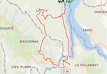

Length
11.3 km

Max alt
917 m

Uphill gradient
602 m
Km-Effort
19.4 km

Min alt
487 m

Downhill gradient
601 m
Boucle
Yes
Creation date :
2021-06-05 08:27:49.871
Updated on :
2021-06-05 12:10:18.864
2h39
Difficulty : Medium

FREE GPS app for hiking
 SityTrail
IGN / Geographical institutes
SityTrail Plus
The world is yours!
About
Trail Walking of 11.3 km to be discovered at Auvergne-Rhône-Alpes, Isère, Treffort. This trail is proposed by maupassant38.
Positioning
Country:
France
Region :
Auvergne-Rhône-Alpes
Department/Province :
Isère
Municipality :
Treffort
Location:
Unknown
Start:(Dec)
Start:(UTM)
711237 ; 4974512 (31T) N.
Comments