


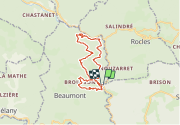
Le Gua La Parot 16km

thonyc
User GUIDE

Length
15.8 km

Max alt
580 m

Uphill gradient
725 m
Km-Effort
25 km

Min alt
263 m

Downhill gradient
716 m
Boucle
Yes
Creation date :
2021-06-05 15:10:12.834
Updated on :
2021-06-07 05:23:01.676
5h53
Difficulty : Difficult

FREE GPS app for hiking
 SityTrail
IGN / Geographical institutes
SityTrail Plus
The world is yours!
About
Trail Walking of 15.8 km to be discovered at Auvergne-Rhône-Alpes, Ardèche, Sanilhac. This trail is proposed by thonyc.
Positioning
Country:
France
Region :
Auvergne-Rhône-Alpes
Department/Province :
Ardèche
Municipality :
Sanilhac
Location:
Unknown
Start:(Dec)
Start:(UTM)
594617 ; 4932789 (31T) N.
Comments