


fontaine ledun

dedejojo
User
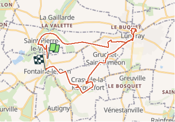

Length
18.1 km

Max alt
105 m

Uphill gradient
164 m
Km-Effort
20 km

Min alt
34 m

Downhill gradient
179 m
Boucle
No
Creation date :
2021-06-06 08:09:44.024
Updated on :
2021-06-06 14:22:01.144
6h10
Difficulty : Very easy

FREE GPS app for hiking
 SityTrail
IGN / Geographical institutes
SityTrail Plus
The world is yours!
About
Trail Walking of 18.1 km to be discovered at Normandy, Seine-Maritime, Fontaine-le-Dun. This trail is proposed by dedejojo.
Positioning
Country:
France
Region :
Normandy
Department/Province :
Seine-Maritime
Municipality :
Fontaine-le-Dun
Location:
Unknown
Start:(Dec)
Start:(UTM)
345460 ; 5520578 (31U) N.
Comments