


Doizieux

JacouBrijou
User
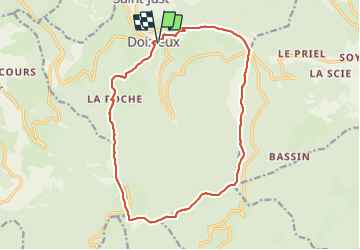

Length
17.2 km

Max alt
1398 m

Uphill gradient
974 m
Km-Effort
30 km

Min alt
582 m

Downhill gradient
974 m
Boucle
Yes
Creation date :
2021-06-08 06:13:13.091
Updated on :
2021-06-08 15:26:27.598
7h20
Difficulty : Medium

FREE GPS app for hiking
 SityTrail
IGN / Geographical institutes
SityTrail Plus
The world is yours!
About
Trail Walking of 17.2 km to be discovered at Auvergne-Rhône-Alpes, Loire, Doizieux. This trail is proposed by JacouBrijou.
Description
17km
Positioning
Country:
France
Region :
Auvergne-Rhône-Alpes
Department/Province :
Loire
Municipality :
Doizieux
Location:
Unknown
Start:(Dec)
Start:(UTM)
624062 ; 5031631 (31T) N.
Comments