


balade meyras

raab
User
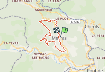

Length
6.6 km

Max alt
550 m

Uphill gradient
237 m
Km-Effort
9.8 km

Min alt
389 m

Downhill gradient
239 m
Boucle
Yes
Creation date :
2021-06-09 07:01:49.554
Updated on :
2021-06-11 09:39:26.05
2h02
Difficulty : Medium

FREE GPS app for hiking
 SityTrail
IGN / Geographical institutes
SityTrail Plus
The world is yours!
About
Trail Walking of 6.6 km to be discovered at Auvergne-Rhône-Alpes, Ardèche, Meyras. This trail is proposed by raab.
Positioning
Country:
France
Region :
Auvergne-Rhône-Alpes
Department/Province :
Ardèche
Municipality :
Meyras
Location:
Unknown
Start:(Dec)
Start:(UTM)
600581 ; 4948266 (31T) N.
Comments