


source de l'huveaune

CABERMAT
User

Length
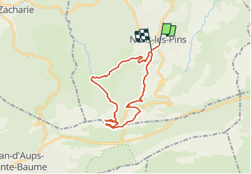
15.2 km

Max alt
706 m

Uphill gradient
610 m
Km-Effort
23 km

Min alt
394 m

Downhill gradient
588 m
Boucle
No
Creation date :
2021-06-09 07:14:23.48
Updated on :
2021-06-09 17:54:55.417
4h37
Difficulty : Difficult

FREE GPS app for hiking
 SityTrail
IGN / Geographical institutes
SityTrail Plus
The world is yours!
About
Trail Walking of 15.2 km to be discovered at Provence-Alpes-Côte d'Azur, Var, Nans-les-Pins. This trail is proposed by CABERMAT.
Positioning
Country:
France
Region :
Provence-Alpes-Côte d'Azur
Department/Province :
Var
Municipality :
Nans-les-Pins
Location:
Unknown
Start:(Dec)
Start:(UTM)
725610 ; 4805771 (31T) N.
Comments