


Ronquerolle Messelan Houdan

avdem
User
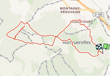

Length
12.7 km

Max alt
176 m

Uphill gradient
268 m
Km-Effort
16.3 km

Min alt
74 m

Downhill gradient
273 m
Boucle
Yes
Creation date :
2021-06-10 07:17:18.914
Updated on :
2021-06-10 10:36:35.888
2h57
Difficulty : Difficult

FREE GPS app for hiking
 SityTrail
IGN / Geographical institutes
SityTrail Plus
The world is yours!
About
Trail Walking of 12.7 km to be discovered at Ile-de-France, Val-d'Oise, Ronquerolles. This trail is proposed by avdem.
Description
long
Photos


Positioning
Country:
France
Region :
Ile-de-France
Department/Province :
Val-d'Oise
Municipality :
Ronquerolles
Location:
Unknown
Start:(Dec)
Start:(UTM)
443206 ; 5446310 (31U) N.
Comments