


villercloye

luckyy
User
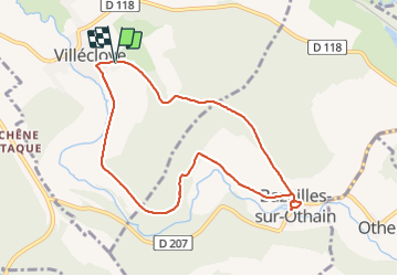

Length
7.8 km

Max alt
302 m

Uphill gradient
166 m
Km-Effort
10 km

Min alt
188 m

Downhill gradient
169 m
Boucle
Yes
Creation date :
2021-06-10 12:07:45.405
Updated on :
2021-06-10 14:26:45.825
2h18
Difficulty : Medium

FREE GPS app for hiking
 SityTrail
IGN / Geographical institutes
SityTrail Plus
The world is yours!
About
Trail Walking of 7.8 km to be discovered at Grand Est, Meuse, Villécloye. This trail is proposed by luckyy.
Positioning
Country:
France
Region :
Grand Est
Department/Province :
Meuse
Municipality :
Villécloye
Location:
Unknown
Start:(Dec)
Start:(UTM)
673854 ; 5487059 (31U) N.
Comments
Boueux voir impraticable le retour. Dommage