Trail Walking Caussols - calern - Photo
 Renefrt
Renefrt

User

© OpenStreetMap contributors
Length
Length
7.7 km
Max alt
Max alt
1277 m
Uphill gradient
Uphill gradient
106 m
Km-Effort
Km-Effort  
9.3 km
Min alt
Min alt
1206 m
Downhill gradient
Downhill gradient
158 m
Boucle
Boucle
No
Creation date :
2021-06-10 06:46:53.33
Updated on :
2021-06-10 16:26:02.201

(0 Reviews)

Walking
Walking
2h07
Difficulty : Very easy

Scan this QR Code to open this trail in the SityTrail application

FREE GPS app for hiking

Logo SityTrail SityTrail

IGN / Geographical institutes

Download SityTrail from the App Store Download SityTrail from Google Play

Logo SityTrail SityTrail World

The world is yours!

Download SityTrail from the App Store Download SityTrail from Google Play Download SityTrail on Huawei AppGallery

About

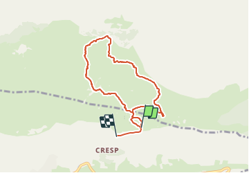
Trail Walking of 7.7 km to be discovered at Provence-Alpes-Côte d'Azur, Maritime Alps, Caussols. This trail is proposed by Renefrt.

Description

problème avec application impossible de l'eteindre.

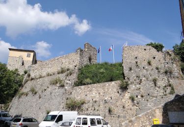
Arrivée et départ au drapeau vert

Elevation profile

Photos

Positioning

Country:
France
Region :
Provence-Alpes-Côte d'Azur
Department/Province :
Maritime Alps
Municipality :
Caussols
Location:
Unknown
Start:(UTM)
332896 ; 4846366 (32T) N.

Trails nearby

Trail Walking Gourdon - Plateau de Cavillore, la Forteresse - Gourdon - Photo
Walking
tracegps

Walking

Medium
(3)
Gourdon, Provence-Alpes-Côte d'Azur, Maritime Alps, France
7.2 km | 11.2 km-effort
2h 15min
Yes
Trail Walking Caussols - Le Haut Montet 1335m, Plateau de Caussols - Photo
Walking
tracegps

Walking

Easy
(1)
Caussols, Provence-Alpes-Côte d'Azur, Maritime Alps, France
13.5 km | 18.6 km-effort
4h 0min
Yes
Trail On foot Gourdon - Plateau de Cavillore - Photo
On foot
PRO

On foot

Easy
Gourdon, Provence-Alpes-Côte d'Azur, Maritime Alps, France
5.9 km | 10 km-effort
2h 16min
Yes
Trail On foot Caussols - Plateau de Caussols - Photo
On foot
PRO

On foot

Easy
Caussols, Provence-Alpes-Côte d'Azur, Maritime Alps, France
13.9 km | 19.1 km-effort
4h 20min
Yes
Trail On foot Cipières - Traversée de l'Estéron - Etape 2 - Photo
On foot
PRO

On foot

Difficult
Cipières, Provence-Alpes-Côte d'Azur, Maritime Alps, France
21 km | 41 km-effort
9h 18min
No
Trail On foot Cipières - Traversée de l'Estéron - Etape 1 - Photo
On foot
PRO

On foot

Medium
Cipières, Provence-Alpes-Côte d'Azur, Maritime Alps, France
18.4 km | 29 km-effort
6h 28min
No
Trail On foot Cipières - Plateau de Calern - Photo
On foot
PRO

On foot

Medium
Cipières, Provence-Alpes-Côte d'Azur, Maritime Alps, France
13.5 km | 21 km-effort
4h 44min
Yes
Trail On foot Gréolières - Circuit du Loup - Photo
On foot
PRO

On foot

Easy
Gréolières, Provence-Alpes-Côte d'Azur, Maritime Alps, France
6.5 km | 12.7 km-effort
2h 52min
Yes
Trail On foot Gréolières - Traversée des Miroirs - Photo
On foot
PRO

On foot

Easy
Gréolières, Provence-Alpes-Côte d'Azur, Maritime Alps, France
6.6 km | 12 km-effort
2h 43min
No


Close
My subscriptions