


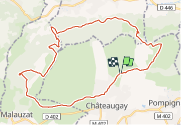
chateauguay champs grimaud puy marcoin

jeanic63
User

Length
12 km

Max alt
557 m

Uphill gradient
259 m
Km-Effort
15.4 km

Min alt
381 m

Downhill gradient
259 m
Boucle
Yes
Creation date :
2021-06-10 11:18:04.64
Updated on :
2021-06-16 20:58:27.1
3h30
Difficulty : Easy

FREE GPS app for hiking
 SityTrail
IGN / Geographical institutes
SityTrail Plus
The world is yours!
About
Trail Walking of 12 km to be discovered at Auvergne-Rhône-Alpes, Puy-de-Dôme, Châteaugay. This trail is proposed by jeanic63.
Description
départ rue du cluzel 200 m avant le stade cluzel
Positioning
Country:
France
Region :
Auvergne-Rhône-Alpes
Department/Province :
Puy-de-Dôme
Municipality :
Châteaugay
Location:
Unknown
Start:(Dec)
Start:(UTM)
506998 ; 5078299 (31T) N.
Comments