


20210611

fredodlageo
User
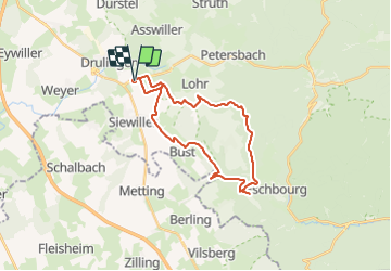

Length
26 km

Max alt
367 m

Uphill gradient
471 m
Km-Effort
32 km

Min alt
200 m

Downhill gradient
470 m
Boucle
Yes
Creation date :
2021-06-11 16:46:56.0
Updated on :
2021-06-11 18:39:38.022
1h52
Difficulty : Difficult

FREE GPS app for hiking
 SityTrail
IGN / Geographical institutes
SityTrail Plus
The world is yours!
About
Trail Mountain bike of 26 km to be discovered at Grand Est, Bas-Rhin, Drulingen. This trail is proposed by fredodlageo.
Description
Sortie vtt
Positioning
Country:
France
Region :
Grand Est
Department/Province :
Bas-Rhin
Municipality :
Drulingen
Location:
Unknown
Start:(Dec)
Start:(UTM)
368504 ; 5413307 (32U) N.
Comments