


Recogne

AnneCecile
User
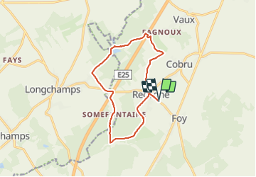

Length
12 km

Max alt
531 m

Uphill gradient
192 m
Km-Effort
14.6 km

Min alt
446 m

Downhill gradient
192 m
Boucle
Yes
Creation date :
2021-06-11 19:38:28.679
Updated on :
2021-06-11 19:46:17.951

FREE GPS app for hiking
 SityTrail
IGN / Geographical institutes
SityTrail Plus
The world is yours!
About
Trail of 12 km to be discovered at Wallonia, Luxembourg, Bastogne. This trail is proposed by AnneCecile.
Positioning
Country:
Belgium
Region :
Wallonia
Department/Province :
Luxembourg
Municipality :
Bastogne
Location:
Unknown
Start:(Dec)
Start:(UTM)
696212 ; 5547743 (31U) N.
Comments