


Cubiéres à Sougraigne

alinetpierre
User
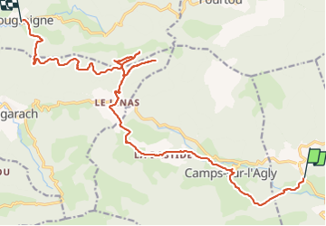

Length
22 km

Max alt
833 m

Uphill gradient
723 m
Km-Effort
31 km

Min alt
399 m

Downhill gradient
753 m
Boucle
No
Creation date :
2021-06-11 06:34:56.174
Updated on :
2021-06-12 08:45:52.397
5h30
Difficulty : Difficult

FREE GPS app for hiking
 SityTrail
IGN / Geographical institutes
SityTrail Plus
The world is yours!
About
Trail Walking of 22 km to be discovered at Occitania, Aude, Cubières-sur-Cinoble. This trail is proposed by alinetpierre.
Description
Via PC a source d'eau salée et les fours verriers, attention au pas del Capelan j'ai fait une erreur un aller retour à ne pas faire.
Positioning
Country:
France
Region :
Occitania
Department/Province :
Aude
Municipality :
Cubières-sur-Cinoble
Location:
Unknown
Start:(Dec)
Start:(UTM)
456042 ; 4745157 (31T) N.
Comments