


Collonges la rouge

Gegetop
User
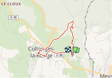

Length
3.6 km

Max alt
278 m

Uphill gradient
84 m
Km-Effort
4.7 km

Min alt
194 m

Downhill gradient
84 m
Boucle
Yes
Creation date :
2021-06-12 11:55:00.862
Updated on :
2021-06-13 11:33:03.237
1h33
Difficulty : Very easy

FREE GPS app for hiking
 SityTrail
IGN / Geographical institutes
SityTrail Plus
The world is yours!
About
Trail Walking of 3.6 km to be discovered at New Aquitaine, Corrèze, Collonges-la-Rouge. This trail is proposed by Gegetop.
Description
Petite boucle permettant d'aller visiter le village en passant par les bois.
Photos


Positioning
Country:
France
Region :
New Aquitaine
Department/Province :
Corrèze
Municipality :
Collonges-la-Rouge
Location:
Unknown
Start:(Dec)
Start:(UTM)
394776 ; 4990434 (31T) N.
Comments