


210613 - Mont Milan

randodan
User
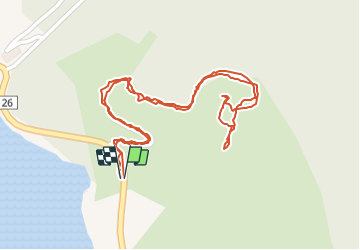

Length
1.6 km

Max alt
1002 m

Uphill gradient
48 m
Km-Effort
2.2 km

Min alt
953 m

Downhill gradient
47 m
Boucle
Yes
Creation date :
2021-06-13 08:01:58.795
Updated on :
2021-06-16 15:02:28.845
1h19
Difficulty : Very easy

FREE GPS app for hiking
 SityTrail
IGN / Geographical institutes
SityTrail Plus
The world is yours!
About
Trail Walking of 1.6 km to be discovered at Occitania, Lozère, Langogne. This trail is proposed by randodan.
Description
Le "1er 1000 m" de l'année ;o)
Positioning
Country:
France
Region :
Occitania
Department/Province :
Lozère
Municipality :
Langogne
Location:
Unknown
Start:(Dec)
Start:(UTM)
565650 ; 4955068 (31T) N.
Comments