


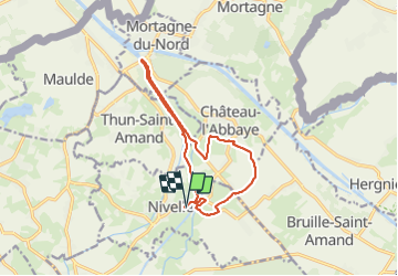
Nivelle- circuit Nivelle-Mortagne-Chateau l'abbaye

papiou
User


2h30
Difficulty : Easy

FREE GPS app for hiking
 SityTrail
IGN / Geographical institutes
SityTrail Plus
The world is yours!
About
Trail Walking of 11.5 km to be discovered at Hauts-de-France, Nord, Nivelle. This trail is proposed by papiou.
Description
circuit proposé par la ville de Nivelle.
RDV halle couverte de la ville et partir vers le pont, passer sur le côté gauche du pont et en suivant la berge de la scarpe rejoindre le pont de Mortagne le traverser et reprendre l'autre rive pour aller à château l'abbaye puis revenir point de départ
Photos


Positioning
Comments