


bau de l'arc

pln30
User

Length
7.8 km

Max alt
931 m

Uphill gradient
483 m
Km-Effort
14.3 km

Min alt
491 m

Downhill gradient
495 m
Boucle
Yes
Creation date :
2021-06-13 07:00:36.696
Updated on :
2022-03-12 11:29:36.541
5h38
Difficulty : Difficult

FREE GPS app for hiking
 SityTrail
IGN / Geographical institutes
SityTrail Plus
The world is yours!
About
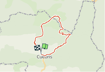
Trail Walking of 7.8 km to be discovered at Provence-Alpes-Côte d'Azur, Maritime Alps, Cuébris. This trail is proposed by pln30.
Description
très belle randonnée variée, avec un départ soutenu, vous trouverez sur ma chaine youtube Air View Channel une vidéo de cette randonnée
Positioning
Country:
France
Region :
Provence-Alpes-Côte d'Azur
Department/Province :
Maritime Alps
Municipality :
Cuébris
Location:
Unknown
Start:(Dec)
Start:(UTM)
340809 ; 4861372 (32T) N.
Comments