


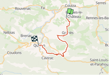
Palhières Quillan

alinetpierre
User

Length
21 km

Max alt
575 m

Uphill gradient
584 m
Km-Effort
29 km

Min alt
288 m

Downhill gradient
682 m
Boucle
No
Creation date :
2021-06-13 06:43:59.63
Updated on :
2021-06-13 14:10:07.505
5h25
Difficulty : Medium

FREE GPS app for hiking
 SityTrail
IGN / Geographical institutes
SityTrail Plus
The world is yours!
About
Trail Walking of 21 km to be discovered at Occitania, Aude, Espéraza. This trail is proposed by alinetpierre.
Description
Palhières Quillan par St Ferréol et St Julia
Positioning
Country:
France
Region :
Occitania
Department/Province :
Aude
Municipality :
Espéraza
Location:
Unknown
Start:(Dec)
Start:(UTM)
438352 ; 4752272 (31T) N.
Comments