


oissel

dedejojo
User
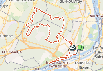

Length
27 km

Max alt
119 m

Uphill gradient
256 m
Km-Effort
30 km

Min alt
2 m

Downhill gradient
255 m
Boucle
Yes
Creation date :
2021-06-13 08:04:45.383
Updated on :
2021-06-13 14:29:01.683
6h22
Difficulty : Very easy

FREE GPS app for hiking
 SityTrail
IGN / Geographical institutes
SityTrail Plus
The world is yours!
About
Trail Walking of 27 km to be discovered at Normandy, Seine-Maritime, Oissel. This trail is proposed by dedejojo.
Positioning
Country:
France
Region :
Normandy
Department/Province :
Seine-Maritime
Municipality :
Oissel
Location:
Unknown
Start:(Dec)
Start:(UTM)
361911 ; 5466881 (31U) N.
Comments