


Pech de Bugarach

alinetpierre
User
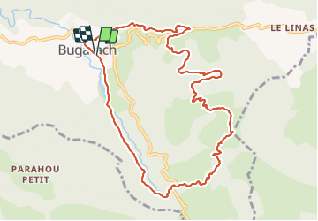

Length
11.9 km

Max alt
1210 m

Uphill gradient
797 m
Km-Effort
23 km

Min alt
461 m

Downhill gradient
798 m
Boucle
Yes
Creation date :
2021-06-14 06:47:49.527
Updated on :
2021-06-14 11:40:49.183
3h44
Difficulty : Difficult

FREE GPS app for hiking
 SityTrail
IGN / Geographical institutes
SityTrail Plus
The world is yours!
About
Trail Walking of 11.9 km to be discovered at Occitania, Aude, Bugarach. This trail is proposed by alinetpierre.
Description
attention au retour nous avons pris un chemin qui a l'arrivée à des maisons est noté privé , à vous de voir ce chemin est noté sur les cartes
Positioning
Country:
France
Region :
Occitania
Department/Province :
Aude
Municipality :
Bugarach
Location:
Unknown
Start:(Dec)
Start:(UTM)
447120 ; 4747118 (31T) N.
Comments