


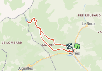
lac de Malrif à partir d Abries

franquen
User

Length
18 km

Max alt
2584 m

Uphill gradient
1146 m
Km-Effort
33 km

Min alt
1552 m

Downhill gradient
1146 m
Boucle
Yes
Creation date :
2021-06-14 07:11:23.882
Updated on :
2021-06-14 15:57:31.874
7h09
Difficulty : Medium

FREE GPS app for hiking
 SityTrail
IGN / Geographical institutes
SityTrail Plus
The world is yours!
About
Trail Walking of 18 km to be discovered at Provence-Alpes-Côte d'Azur, Hautes-Alpes, Abriès-Ristolas. This trail is proposed by franquen.
Positioning
Country:
France
Region :
Provence-Alpes-Côte d'Azur
Department/Province :
Hautes-Alpes
Municipality :
Abriès-Ristolas
Location:
Unknown
Start:(Dec)
Start:(UTM)
335999 ; 4962231 (32T) N.
Comments