


Murs 14 juin 2021 (IBP

TRIMAILLE
User
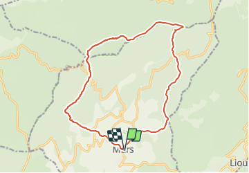

Length
17.8 km

Max alt
789 m

Uphill gradient
530 m
Km-Effort
25 km

Min alt
445 m

Downhill gradient
530 m
Boucle
Yes
Creation date :
2021-06-14 05:36:43.47
Updated on :
2021-06-22 15:30:01.765
5h19
Difficulty : Medium

FREE GPS app for hiking
 SityTrail
IGN / Geographical institutes
SityTrail Plus
The world is yours!
About
Trail Walking of 17.8 km to be discovered at Provence-Alpes-Côte d'Azur, Vaucluse, Murs. This trail is proposed by TRIMAILLE.
Positioning
Country:
France
Region :
Provence-Alpes-Côte d'Azur
Department/Province :
Vaucluse
Municipality :
Murs
Location:
Unknown
Start:(Dec)
Start:(UTM)
679992 ; 4868853 (31T) N.
Comments