


210616 - Sentier des Fées

randodan
User
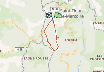

Length
4.3 km

Max alt
1149 m

Uphill gradient
70 m
Km-Effort
5.2 km

Min alt
1095 m

Downhill gradient
71 m
Boucle
Yes
Creation date :
2021-06-16 07:48:43.629
Updated on :
2021-06-16 14:35:58.634
2h08
Difficulty : Very easy

FREE GPS app for hiking
 SityTrail
IGN / Geographical institutes
SityTrail Plus
The world is yours!
About
Trail Walking of 4.3 km to be discovered at Occitania, Lozère, Saint-Flour-de-Mercoire. This trail is proposed by randodan.
Photos


Positioning
Country:
France
Region :
Occitania
Department/Province :
Lozère
Municipality :
Saint-Flour-de-Mercoire
Location:
Unknown
Start:(Dec)
Start:(UTM)
564640 ; 4949136 (31T) N.
Comments