


orsiére 16 juin 21

Valmeinier
User
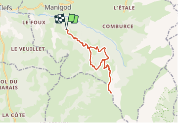

Length
15.2 km

Max alt
1748 m

Uphill gradient
785 m
Km-Effort
26 km

Min alt
1163 m

Downhill gradient
785 m
Boucle
Yes
Creation date :
2021-06-16 07:19:47.503
Updated on :
2021-06-16 12:58:17.829
5h37
Difficulty : Very difficult

FREE GPS app for hiking
 SityTrail
IGN / Geographical institutes
SityTrail Plus
The world is yours!
About
Trail Walking of 15.2 km to be discovered at Auvergne-Rhône-Alpes, Upper Savoy, Manigod. This trail is proposed by Valmeinier.
Positioning
Country:
France
Region :
Auvergne-Rhône-Alpes
Department/Province :
Upper Savoy
Municipality :
Manigod
Location:
Unknown
Start:(Dec)
Start:(UTM)
296257 ; 5080729 (32T) N.
Comments