


Bourlatier 18/06/21

Linerou
User
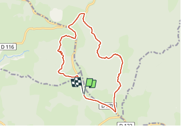

Length
8.7 km

Max alt
1454 m

Uphill gradient
228 m
Km-Effort
11.7 km

Min alt
1284 m

Downhill gradient
223 m
Boucle
Yes
Creation date :
2021-06-17 07:06:42.371
Updated on :
2021-06-17 10:36:37.648
2h33
Difficulty : Medium

FREE GPS app for hiking
 SityTrail
IGN / Geographical institutes
SityTrail Plus
The world is yours!
About
Trail Walking of 8.7 km to be discovered at Auvergne-Rhône-Alpes, Ardèche, Sagnes-et-Goudoulet. This trail is proposed by Linerou.
Positioning
Country:
France
Region :
Auvergne-Rhône-Alpes
Department/Province :
Ardèche
Municipality :
Sagnes-et-Goudoulet
Location:
Unknown
Start:(Dec)
Start:(UTM)
597203 ; 4964203 (31T) N.
Comments