


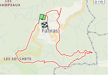
Fabras

MoiClaude
User

Length
6.4 km

Max alt
538 m

Uphill gradient
239 m
Km-Effort
9.7 km

Min alt
324 m

Downhill gradient
253 m
Boucle
No
Creation date :
2021-06-17 08:29:50.891
Updated on :
2021-06-17 12:26:57.844
1h49
Difficulty : Medium

FREE GPS app for hiking
 SityTrail
IGN / Geographical institutes
SityTrail Plus
The world is yours!
About
Trail Walking of 6.4 km to be discovered at Auvergne-Rhône-Alpes, Ardèche, Fabras. This trail is proposed by MoiClaude.
Description
Rando agréable.
Positioning
Country:
France
Region :
Auvergne-Rhône-Alpes
Department/Province :
Ardèche
Municipality :
Fabras
Location:
Unknown
Start:(Dec)
Start:(UTM)
602014 ; 4945012 (31T) N.
Comments
Rando détente de 6,4 km.