


ROCHEFORT - Ste Odille+Lorette 2021

fra_depoorter
User
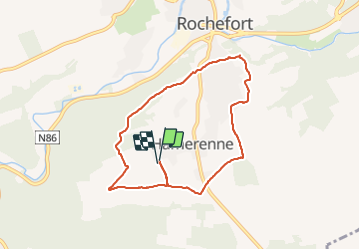

Length
7.1 km

Max alt
323 m

Uphill gradient
142 m
Km-Effort
8.9 km

Min alt
212 m

Downhill gradient
141 m
Boucle
Yes
Creation date :
2021-06-17 07:32:11.41
Updated on :
2021-06-17 13:08:33.769
1h54
Difficulty : Easy

FREE GPS app for hiking
 SityTrail
IGN / Geographical institutes
SityTrail Plus
The world is yours!
About
Trail Walking of 7.1 km to be discovered at Wallonia, Namur, Rochefort. This trail is proposed by fra_depoorter.
Description
Marcheurs de la Haute Lesse le 16/06/2021.
Positioning
Country:
Belgium
Region :
Wallonia
Department/Province :
Namur
Municipality :
Rochefort
Location:
Unknown
Start:(Dec)
Start:(UTM)
658180 ; 5556965 (31U) N.
Comments