


20210617-Mauny

doudet
User
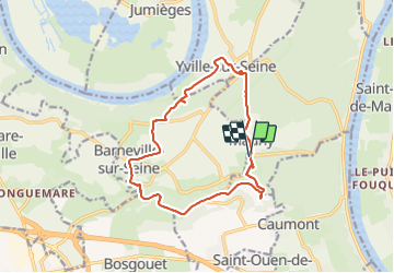

Length
13.4 km

Max alt
143 m

Uphill gradient
272 m
Km-Effort
17.1 km

Min alt
3 m

Downhill gradient
272 m
Boucle
Yes
Creation date :
2021-06-17 11:51:40.751
Updated on :
2021-06-18 07:29:13.486
3h56
Difficulty : Medium

FREE GPS app for hiking
 SityTrail
IGN / Geographical institutes
SityTrail Plus
The world is yours!
About
Trail Walking of 13.4 km to be discovered at Normandy, Seine-Maritime, Mauny. This trail is proposed by doudet.
Description
Boucle A-R au départ de la Mairie de Mauny
Photos


Positioning
Country:
France
Region :
Normandy
Department/Province :
Seine-Maritime
Municipality :
Mauny
Location:
Unknown
Start:(Dec)
Start:(UTM)
346532 ; 5471880 (31U) N.
Comments