


2021-06-18_08h59m31_0SYBqLIqzQk

Gegetop
User
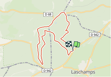

Length
9.1 km

Max alt
1111 m

Uphill gradient
228 m
Km-Effort
12.2 km

Min alt
976 m

Downhill gradient
243 m
Boucle
Yes
Creation date :
2021-06-18 06:59:32.139
Updated on :
2021-06-18 15:13:44.055
2h45
Difficulty : Difficult

FREE GPS app for hiking
 SityTrail
IGN / Geographical institutes
SityTrail Plus
The world is yours!
About
Trail Walking of 9.1 km to be discovered at Auvergne-Rhône-Alpes, Puy-de-Dôme, Saint-Genès-Champanelle. This trail is proposed by Gegetop.
Description
Une randonnée tout en forêt sur des chemins peu fréquentés et sans difficulté.
Photos

Positioning
Country:
France
Region :
Auvergne-Rhône-Alpes
Department/Province :
Puy-de-Dôme
Municipality :
Saint-Genès-Champanelle
Location:
Unknown
Start:(Dec)
Start:(UTM)
496948 ; 5066141 (31T) N.
Comments