


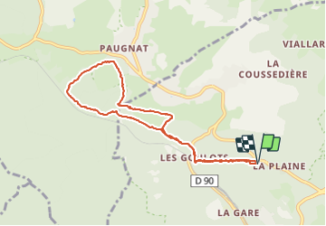
Le tour du Puy de Paugnat (World beta)

Gegetop
User

Length
8.4 km

Max alt
821 m

Uphill gradient
173 m
Km-Effort
10.7 km

Min alt
695 m

Downhill gradient
172 m
Boucle
Yes
Creation date :
2021-06-18 07:47:17.652
Updated on :
2021-06-18 09:57:36.661
1h36
Difficulty : Very easy

FREE GPS app for hiking
 SityTrail
IGN / Geographical institutes
SityTrail Plus
The world is yours!
About
Trail Nordic walking of 8.4 km to be discovered at Auvergne-Rhône-Alpes, Puy-de-Dôme, Volvic. This trail is proposed by Gegetop.
Description
Départ sur le sentier du Dr Moity à la Plaine.
Marche nordique.
5.2km/h
Photos
 - Photo 1")
Positioning
Country:
France
Region :
Auvergne-Rhône-Alpes
Department/Province :
Puy-de-Dôme
Municipality :
Volvic
Location:
Unknown
Start:(Dec)
Start:(UTM)
500575 ; 5079662 (31T) N.
Comments