Trail Walking Entremont-le-Vieux - Refuge de l'Alpette - Photo
 crocau
crocau

User

© OpenStreetMap contributors
Length
Length
5.7 km
Max alt
Max alt
1540 m
Uphill gradient
Uphill gradient
511 m
Km-Effort
Km-Effort  
12.5 km
Min alt
Min alt
1098 m
Downhill gradient
Downhill gradient
492 m
Boucle
Boucle
Yes
Creation date :
2021-06-20 06:01:32.556
Updated on :
2021-06-20 11:10:36.743

(0 Reviews)

Walking
Walking
2h17
Difficulty : Difficult

Scan this QR Code to open this trail in the SityTrail application

FREE GPS app for hiking

Logo SityTrail SityTrail

IGN / Geographical institutes

Download SityTrail from the App Store Download SityTrail from Google Play

Logo SityTrail SityTrail Plus

The world is yours!

Download SityTrail from the App Store Download SityTrail from Google Play Download SityTrail on Huawei AppGallery

About

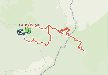
Trail Walking of 5.7 km to be discovered at Auvergne-Rhône-Alpes, Savoy, Entremont-le-Vieux. This trail is proposed by crocau.

Description

Inspirée par le livre " 52 balades en famille autour de Grenoble" cette rando est une grosse bavante . Un dénivelé moyen  mais sur 3 km, ça rétame un peu.  De la Plagne jusqu'en haut où l'on découvre cette clairière, son chalet et sa cabane ( refuge) ..

Elevation profile

Photos

Positioning

Country:
France
Region :
Auvergne-Rhône-Alpes
Department/Province :
Savoy
Municipality :
Entremont-le-Vieux
Location:
Unknown
Start:(UTM)
727239 ; 5036109 (31T) N.


Close
My subscriptions