


2021-06-20 Rando Dourdan

jchezlemas
User
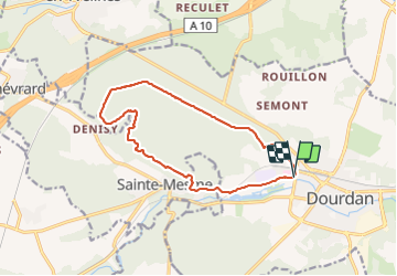

Length
13.1 km

Max alt
179 m

Uphill gradient
168 m
Km-Effort
15.3 km

Min alt
98 m

Downhill gradient
170 m
Boucle
Yes
Creation date :
2021-06-20 12:40:50.116
Updated on :
2021-06-20 16:12:34.558
3h30
Difficulty : Easy

FREE GPS app for hiking
 SityTrail
IGN / Geographical institutes
SityTrail Plus
The world is yours!
About
Trail Walking of 13.1 km to be discovered at Ile-de-France, Essonne, Dourdan. This trail is proposed by jchezlemas.
Positioning
Country:
France
Region :
Ile-de-France
Department/Province :
Essonne
Municipality :
Dourdan
Location:
Unknown
Start:(Dec)
Start:(UTM)
426254 ; 5376039 (31U) N.
Comments