


7777777779 15:21:17

UDGI54
User
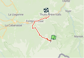

Length
18.5 km

Max alt
2387 m

Uphill gradient
805 m
Km-Effort
33 km

Min alt
836 m

Downhill gradient
1799 m
Boucle
No
Creation date :
2021-06-20 19:40:58.122
Updated on :
2021-06-20 19:49:33.046

FREE GPS app for hiking
 SityTrail
IGN / Geographical institutes
SityTrail Plus
The world is yours!
About
Trail of 18.5 km to be discovered at Occitania, Pyrénées-Orientales, Fontpédrouse. This trail is proposed by UDGI54.
Positioning
Country:
France
Region :
Occitania
Department/Province :
Pyrénées-Orientales
Municipality :
Fontpédrouse
Location:
Unknown
Start:(Dec)
Start:(UTM)
436193 ; 4701627 (31T) N.
Comments