


Val Ceny

dewaeph
User
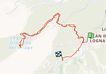

Length
3.6 km

Max alt
1832 m

Uphill gradient
200 m
Km-Effort
6.1 km

Min alt
1671 m

Downhill gradient
155 m
Boucle
No
Creation date :
2021-06-22 07:36:30.365
Updated on :
2021-06-22 10:19:35.455
2h42
Difficulty : Medium

FREE GPS app for hiking
 SityTrail
IGN / Geographical institutes
SityTrail Plus
The world is yours!
About
Trail Walking of 3.6 km to be discovered at Aosta Valley, Unknown, Courmayeur. This trail is proposed by dewaeph.
Positioning
Country:
Italy
Region :
Aosta Valley
Department/Province :
Unknown
Municipality :
Courmayeur
Location:
Unknown
Start:(Dec)
Start:(UTM)
336764 ; 5072363 (32T) N.
Comments