


Environ de Maxou

fxhedon
User
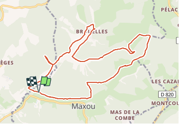

Length
12.4 km

Max alt
337 m

Uphill gradient
232 m
Km-Effort
15.4 km

Min alt
184 m

Downhill gradient
227 m
Boucle
Yes
Creation date :
2021-06-19 07:36:32.0
Updated on :
2021-06-23 08:17:45.623
3h04
Difficulty : Very easy

FREE GPS app for hiking
 SityTrail
IGN / Geographical institutes
SityTrail Plus
The world is yours!
About
Trail Walking of 12.4 km to be discovered at Occitania, Lot, Maxou. This trail is proposed by fxhedon.
Description
Très belle promenade sur vallons et plateau
Positioning
Country:
France
Region :
Occitania
Department/Province :
Lot
Municipality :
Maxou
Location:
Unknown
Start:(Dec)
Start:(UTM)
375065 ; 4932989 (31T) N.
Comments