


Pont d'ouilly chemin du Roy

lepompi
User

Length
9.9 km

Max alt
207 m

Uphill gradient
288 m
Km-Effort
13.8 km

Min alt
72 m

Downhill gradient
293 m
Boucle
Yes
Creation date :
2021-06-24 14:42:23.143
Updated on :
2021-06-24 14:46:27.464
3h08
Difficulty : Easy

FREE GPS app for hiking
 SityTrail
IGN / Geographical institutes
SityTrail Plus
The world is yours!
About
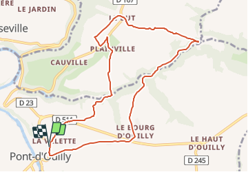
Trail On foot of 9.9 km to be discovered at Normandy, Calvados, Pont-d'Ouilly. This trail is proposed by lepompi.
Description
D'apres le tracé de Magny que j,ai corrigé
Sympa ,routes tres peu fréquentées !
bonne partie sur chemins
Positioning
Country:
France
Region :
Normandy
Department/Province :
Calvados
Municipality :
Pont-d'Ouilly
Location:
Unknown
Start:(Dec)
Start:(UTM)
690093 ; 5416957 (30U) N.
Comments