


Mâcher

audrey54
User
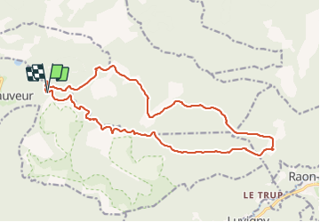

Length
19.1 km

Max alt
715 m

Uphill gradient
500 m
Km-Effort
26 km

Min alt
343 m

Downhill gradient
500 m
Boucle
Yes
Creation date :
2021-06-25 07:08:48.0
Updated on :
2021-06-25 11:20:34.062
3h41
Difficulty : Very difficult

FREE GPS app for hiking
 SityTrail
IGN / Geographical institutes
SityTrail Plus
The world is yours!
About
Trail Walking of 19.1 km to be discovered at Grand Est, Meurthe-et-Moselle, Saint-Sauveur. This trail is proposed by audrey54.
Description
Fourche mâcher
Positioning
Country:
France
Region :
Grand Est
Department/Province :
Meurthe-et-Moselle
Municipality :
Saint-Sauveur
Location:
Unknown
Start:(Dec)
Start:(UTM)
351855 ; 5377650 (32U) N.
Comments