


12875011-Igny par Vauboyen

c.chehere
User
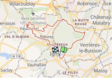

Length
15.9 km

Max alt
180 m

Uphill gradient
296 m
Km-Effort
19.8 km

Min alt
63 m

Downhill gradient
295 m
Boucle
Yes
Creation date :
2021-06-26 16:42:41.566
Updated on :
2021-06-26 16:44:57.284
4h29
Difficulty : Medium

FREE GPS app for hiking
 SityTrail
IGN / Geographical institutes
SityTrail Plus
The world is yours!
About
Trail Walking of 15.9 km to be discovered at Ile-de-France, Essonne, Igny. This trail is proposed by c.chehere.
Description
Au départ de la gare d'Igny
Positioning
Country:
France
Region :
Ile-de-France
Department/Province :
Essonne
Municipality :
Igny
Location:
Unknown
Start:(Dec)
Start:(UTM)
443484 ; 5398867 (31U) N.
Comments