


Madine. Anoë

lorenzot54
User
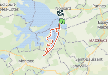

Length
9.6 km

Max alt
234 m

Uphill gradient
25 m
Km-Effort
9.9 km

Min alt
215 m

Downhill gradient
33 m
Boucle
No
Creation date :
2021-06-26 14:47:28.0
Updated on :
2021-06-26 20:11:02.708
5h23
Difficulty : Unknown

FREE GPS app for hiking
 SityTrail
IGN / Geographical institutes
SityTrail Plus
The world is yours!
About
Trail Canoe - kayak of 9.6 km to be discovered at Grand Est, Meurthe-et-Moselle, Pannes. This trail is proposed by lorenzot54.
Positioning
Country:
France
Region :
Grand Est
Department/Province :
Meurthe-et-Moselle
Municipality :
Pannes
Location:
Unknown
Start:(Dec)
Start:(UTM)
701987 ; 5421811 (31U) N.
Comments