


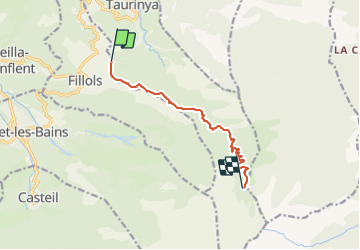
col de miliere cortalets

UDGI54
User

Length
8.8 km

Max alt
2158 m

Uphill gradient
1327 m
Km-Effort
22 km

Min alt
845 m

Downhill gradient
18 m
Boucle
No
Creation date :
2021-06-27 18:51:47.302
Updated on :
2021-06-27 18:52:26.595
5h01
Difficulty : Very difficult

FREE GPS app for hiking
 SityTrail
IGN / Geographical institutes
SityTrail Plus
The world is yours!
About
Trail Walking of 8.8 km to be discovered at Occitania, Pyrénées-Orientales, Fillols. This trail is proposed by UDGI54.
Positioning
Country:
France
Region :
Occitania
Department/Province :
Pyrénées-Orientales
Municipality :
Fillols
Location:
Unknown
Start:(Dec)
Start:(UTM)
452369 ; 4712814 (31T) N.
Comments