


Du Pison aux Econdus 17km

thonyc
User GUIDE
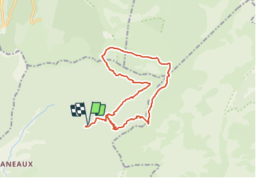

Length
16.8 km

Max alt
1673 m

Uphill gradient
927 m
Km-Effort
29 km

Min alt
1006 m

Downhill gradient
925 m
Boucle
Yes
Creation date :
2021-06-29 16:50:05.043
Updated on :
2021-06-29 17:14:25.072
6h37
Difficulty : Difficult

FREE GPS app for hiking
 SityTrail
IGN / Geographical institutes
SityTrail Plus
The world is yours!
About
Trail Walking of 16.8 km to be discovered at Auvergne-Rhône-Alpes, Drôme, Romeyer. This trail is proposed by thonyc.
Positioning
Country:
France
Region :
Auvergne-Rhône-Alpes
Department/Province :
Drôme
Municipality :
Romeyer
Location:
Unknown
Start:(Dec)
Start:(UTM)
693475 ; 4964364 (31T) N.
Comments