


-wWqhxp08Y8

Linerou
User
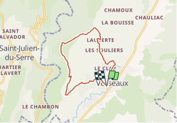

Length
6.9 km

Max alt
447 m

Uphill gradient
215 m
Km-Effort
9.8 km

Min alt
263 m

Downhill gradient
216 m
Boucle
Yes
Creation date :
2021-06-30 13:16:21.853
Updated on :
2021-06-30 13:20:21.166
2h13
Difficulty : Medium

FREE GPS app for hiking
 SityTrail
IGN / Geographical institutes
SityTrail Plus
The world is yours!
About
Trail Walking of 6.9 km to be discovered at Auvergne-Rhône-Alpes, Ardèche, Vesseaux. This trail is proposed by Linerou.


Positioning
Country:
France
Region :
Auvergne-Rhône-Alpes
Department/Province :
Ardèche
Municipality :
Vesseaux
Location:
Unknown
Start:(Dec)
Start:(UTM)
614143 ; 4945042 (31T) N.
Comments