


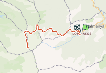
els masos de valmanya le pic du canigou par le chemin foréstier

jeanic63
User

Length
23 km

Max alt
2753 m

Uphill gradient
1740 m
Km-Effort
46 km

Min alt
1048 m

Downhill gradient
1735 m
Boucle
Yes
Creation date :
2021-07-02 14:44:26.156
Updated on :
2021-07-02 14:48:57.428
10h24
Difficulty : Very difficult

FREE GPS app for hiking
 SityTrail
IGN / Geographical institutes
SityTrail Plus
The world is yours!
About
Trail On foot of 23 km to be discovered at Occitania, Pyrénées-Orientales, Valmanya. This trail is proposed by jeanic63.
Description
départ parking de els masos de valmanya
Positioning
Country:
France
Region :
Occitania
Department/Province :
Pyrénées-Orientales
Municipality :
Valmanya
Location:
Unknown
Start:(Dec)
Start:(UTM)
460484 ; 4708856 (31T) N.
Comments