


Trail Annecy - Semnoz

gregou74
User
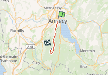

Length
17.5 km

Max alt
1692 m

Uphill gradient
1329 m
Km-Effort
32 km

Min alt
456 m

Downhill gradient
290 m
Boucle
No
Creation date :
2021-07-03 18:32:18.881
Updated on :
2021-07-03 18:45:43.189
--
Difficulty : Difficult

FREE GPS app for hiking
 SityTrail
IGN / Geographical institutes
SityTrail Plus
The world is yours!
About
Trail Trail of 17.5 km to be discovered at Auvergne-Rhône-Alpes, Upper Savoy, Annecy. This trail is proposed by gregou74.
Positioning
Country:
France
Region :
Auvergne-Rhône-Alpes
Department/Province :
Upper Savoy
Municipality :
Annecy
Location:
Annecy
Start:(Dec)
Start:(UTM)
277280 ; 5086711 (32T) N.
Comments