


Rando des lacs

audrey54
User
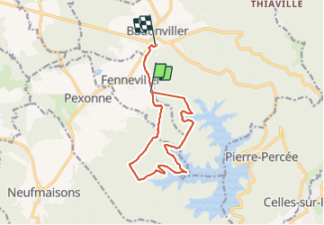

Length
11.9 km

Max alt
431 m

Uphill gradient
218 m
Km-Effort
15 km

Min alt
311 m

Downhill gradient
273 m
Boucle
No
Creation date :
2021-07-04 09:01:52.0
Updated on :
2021-07-04 11:30:48.361
2h28
Difficulty : Difficult

FREE GPS app for hiking
 SityTrail
IGN / Geographical institutes
SityTrail Plus
The world is yours!
About
Trail Walking of 11.9 km to be discovered at Grand Est, Meurthe-et-Moselle, Fenneviller. This trail is proposed by audrey54.
Positioning
Country:
France
Region :
Grand Est
Department/Province :
Meurthe-et-Moselle
Municipality :
Fenneviller
Location:
Unknown
Start:(Dec)
Start:(UTM)
344101 ; 5372322 (32U) N.
Comments